Mario Picazo warns for the coming hours: rain is coming to these areas of Spain
After the farewell to the storm Ivo, an active DANA will bring rain to the north, center, and south of the country this Sunday
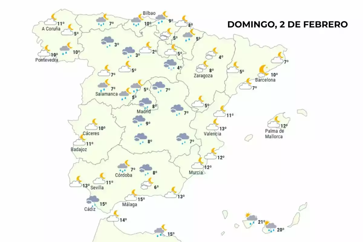
Spain has already bid farewell to storm Ivo, but the bad weather doesn't let up. According to Mario Picazo, a new DANA has arrived on the Peninsula, leaving an unstable outlook throughout next weekend. In the coming hours, rain will be the main feature in much of the country, with a particular impact in the north, center, and some southern areas.
Temperatures will continue to drop, with colder values in the interior and a milder environment in the south and the islands. However, the main feature of today's day will be the rain. In total, at least ten autonomous communities will record rain throughout the day, with overcast skies and temperatures that in some places won't exceed 5 degrees (41 degrees Fahrenheit).

"We will have, therefore, some rain next weekend, but there won't be any intense precipitation," assured Mario Picazo. Thus, some autonomous communities will need to open their umbrellas over the next few hours.
Rain will arrive during the next few hours in these 10 areas of Spain
Tomorrow, February 2, the north of Spain will be one of the territories most affected by the DANA. Galicia, Asturias, Cantabria, and the Basque Country will have intermittent rain throughout the day. In these regions, the environment will be cold, with minimums of 3 degrees (37.4 degrees Fahrenheit) in the interior and maximums barely reaching 10 degrees (50 degrees Fahrenheit).
Castilla y León will also be among the affected areas, especially in provinces like León and Burgos. Here the rain will be light, but the environment will remain wintry, with thermometers ranging between 3 and 5 degrees (37.4 and 41 degrees Fahrenheit). The sky is expected to remain mostly overcast throughout the day.
Madrid and Castilla-La Mancha will also be under the influence of this rain episode. In the capital, gray skies and light rain will mark the day, with temperatures not exceeding 9 degrees (48.2 degrees Fahrenheit). In Cuenca and Toledo, the situation will be similar, with a humid and cool environment that will persist until the end of the day.

Further south, the rain will reach some areas of Andalusia. Córdoba and Cádiz will see occasional rain, although it won't be as persistent as in the north. In contrast, in cities like Málaga and Seville, the weather will be more variable, alternating clouds and clear skies. Temperatures will be more pleasant, with maximums that could reach 15 degrees (59 degrees Fahrenheit).
In the Canary Islands, there will also be rain in some areas, although temperatures will remain milder than on the Peninsula. In the western islands, the mercury will rise to 21 degrees (69.8 degrees Fahrenheit), with cloudy skies and some scattered showers.
Meanwhile, on the Mediterranean coast, the weather will be more stable. Cities like Barcelona, Zaragoza, Valencia, and Palma de Mallorca won't record rain, although the sky will be partially overcast at times during the day. In these regions, temperatures will range between 7 and 13 degrees (44.6 and 55.4 degrees Fahrenheit), without abrupt changes compared to previous days.

A wintry day with thermal contrasts, according to Mario Picazo
The coldest minimums will be recorded in the interior of the peninsula, especially in areas of Castilla y León —Cuenca, Soria, or León— and Aragón. In these communities, thermometers will mark between 3 and 4 degrees (37.4 and 39.2 degrees Fahrenheit) in the early hours of the day.
In contrast, in the south and in the Canary Islands, the environment will be much milder. Temperatures could reach 21 degrees (69.8 degrees Fahrenheit) in the islands and 15 degrees (59 degrees Fahrenheit) in some areas of Andalusia. Even so, the weather will be unstable, with cloudy skies and possible rain.
Thus, the west and north of the country will be the most affected by the rain over the next few hours. Although these are light showers, they will require opening umbrellas in some regions of Spain.
More posts: